Tuesday, September 14, 2010

Finished!!!!


Done!!!!! What a trip! It was an epic journey with many ups and downs (besides the obvious mountain reference). The last week added the additional challenge of more rain and mice/rats at the highly used campsites in that section. Which led to many sleepless nights. The very last night my hiking partner woke up screaming due to a mouse on her, which in turn woke me up screaming. Hopefully no one was camping nearby, they would have thought the worst!

After finishing, I took a bus to Vancouver, then to Seattle. In Seattle I hung out with some friends and saw a bit o
f the city.

So what did I learn from this trip? There are plenty of good people out there: other hikers, hostel owners, people willing to pick up smelly hikers for rides, my folks for sending me gear. I learned that I am willing to carry toilette paper. I didn't use it for the first half of the trip, until I acquired giardia and was making pit stops more than 4 times a day
. I learned it is worth carrying tons of food. All of the lightweight gear that
I have is great, but the weight of food is necessary.

This pic is actually of my hiking partner Kerry. This was crossing a river in Washington on a slippery log. She loved every minute of it!!
Numbers:
Pacific Crest Trail: 2656 miles
Total days: 140
Days off during: 18
Days hiking: 122
Longest Day: 33 miles
Shortest: 6 miles
Average miles per day including days off: 19

Off to see more family and friends! Happy trails to all and thanks for all of the support. I thought of everyone while I was out there.


Wednesday, September 1, 2010

One more post for Washington!


Washington has been beautiful!! It hasn't been as easy as the terrain in Oregon where the average mileage was 30 per day, but much more spectacular, rugged terrain. The landscape is more lush, and densely forested (at least where the PCT goes) than Oregon.


During one day of hiking, there was a 100 mile
trail-running-race. Although we had to hop off the trail every no
w and then to let a runner pass, we did get to take advantage of the aid stations set up every 7 miles. They were stocked with sweets, sandwiches, soda, and the last one just before bed had tomato soup!! A treat when that night it got down below freezing. One time when we hopped off we picked some huckleberries (taste like blueberries) and one of the racers joined us!!

Skykomish, mile 2,476


We just got into town today, soaking wet! It has been raining for the last two days. What does this mean? This means showing up to camp and trying to set up the tent in the pouring rain. Then getting into said tent without bringing any rain in with you. Tough. And hopefully your ground cloth, a moisture barrier between the tent and the ground, covers the floor underneath your tent but does not extend beyond the tent walls. If it does, rain will catch and draw underneath your tent. If it doesn't cover the floor
the wet ground will soak through, and you and your possessions (sleeping bag) will get wet. All of this happened. On top of that we had to start our day off putting on our wet clothes during the cold morning. And one last element to our blissful night of sleep: 2 mice that ransacked our food bags at 3 am.
O.K., there is my complaining rant. I have to remember I am on a beautiful trail 99% of the time, breathing fresh air, eating tons of food. Speaking of that, I was able to consume 6,000 calories a day for 3 days while hiking. Very gratifying on the trail where I am typically hungry until I get to town. Here is the list: 7 cliff bars, 2 peanut butter sandwiches, 1 bag of cool ranch Doritos, 3 cheese sandwiches, and mac-n-cheese dinner with butter. The down side is the increased bowel movements.

Anyways, 10 days to go!!!! I just hope we have good weather to see this beautiful country!

Thursday, August 19, 2010

Washington, 21 days to go!!!


Hello all, I know, not enough posts. This will probably be the last one until I am finished, which will probably be September 9 or 10.


Oregon: super beautiful and super easy to do large miles. We averaged 30 miles a day and never took a day off. The trail seemed to go through long spells of forest and then emerge to large volcanic mountains with epic names such as Theilson, Hood, Washington, and Jefferson. We have seen many more section hikers due to the fair weather and an the outdoorsy population of Oregon. Many of them are interested in thru-hiking, but sometimes we are trying to make the miles and have to cut the chats short. The wildlife has tapered a bit, except for the rodents. We were hiking along Eagle Creek, a beautiful alternative to the PCT for 14 miles, and had several mice invade our campsites. One location was so bad that we packed up at 1 am and moved an hour away. To our dismay, the mice followed. But by the time we were to aggrevated the sun was up and we hiked on anyway. We also hiked along crater lake, the deepest lake in the U.S., 7th in the world at close to 2000 feet. It used to be a volcanic mountain that blew its' top. Swimming in lakes and rivers, lunchtime naps, and laughing at the ordinary have become staples of daily life. I have come to accept my addiction to caffeine instead of trying to quit on this trail. I make tea twice a day to the equivalent of 3 cups of coffee. I only wish I had done it sooner, like in the Sierras!!!


Today I am camping in a Best Western with my fellow hiker Beaker. I slept for 10 hours, probably have eaten 10,000 calories, and watched 4 movies. A good, mindless break. We may take one more day off in Washington, and average about 25 miles a day. Highlights will be Mt. Rainer, Mt Adams, Goat Rocks, the Cascade Mountains, and Glacier Peak.


Every day is different on the trail. Not always the terrain, but the thoughts of home, friends, and anything outside of backpacking. It allows your mind to wander, and although I may not find answers out here, I can figure out what is next. And what is next right now is lunch and some sleep!!! (Maybe a beer or six too).

Friday, July 23, 2010

Mount Shasta!

I am at mile 1510! Over half way now and only a few hundred left in Cali! I should be in Oregon in 10 days. Well, after a whirlwind trip back to Florida: 2 days of flying, 2 days of hitch-hiking, and 5 days in FL (wedding, work, baby sighting-Calina) I got back on the trail exhausted. I ended up with giardia, a parasite that lives in your intestines and causes the evacuation of everything, and had to obtain antibiotics to get rid of it (thanks JT). All better now but hiking on antibiotics was not fun. I am stepping up the mileages now to average 25 per day. The terrain has levelled out but the heat has picked up, but nothing compared to FL. I did take a short greyhound ride that was one of the worst experiences of my life. The only seat was in the rear of a packed bus. Unfortunately the bathroom door would never close, and seems to have not been cleaned in a month. The hitches were great, a farmer, construction worker, an ex-con, a not-for-profit manager, and logger. Amazingly a quarter of my hitches have been from firefighters.

Last week I had to night hike to make it to a post office in a small town called Old Station. About midnight my headlamp flashed some gold eyes, turns out it was a bear!! A few loud noises with my trekking pole scared him off. I was on my toes after that, and in the days since I have spotted 2 more. In that same town is a trail angel named Gorgi. She is an older woman who takes in hikers and cooks breakfast and dinner for them. So I stayed the night and hiked out the next morning. 5 miles later I was at a restaurant eating my second breakfast-best on the trail-breakfast burrito covered in country gravy! Another mile later I was in a cave formed by an old lava tube. In this cave the temp was 60 degrees while outside it was 100! I and another hiker spent 4 hours in there wasting the afternoon away. This cave had a parking lot for tourists, so we went to solicit a ride back to town to eat lunch! By 4 pm, and being awake since 5:30 am, we had made it 5 miles!! And been to the same town 3 times in 1 day. Sometimes you just follow your stomach.

And I wanted to thank my crew at station 1A for their warm welcome and intriguing sense of humor! One word, demented!

On that note, off to dinner for beer and burgers...

Peace!!!

Saturday, July 10, 2010

The snow has subsided!!


Hello all! With the continuation of long days and lack of computer access, blogging was nearly impossible. A lot of hikers have smart phones and will write their journals at night on them, then once they reach town will turn them on and download their entries. I am not so lucky.
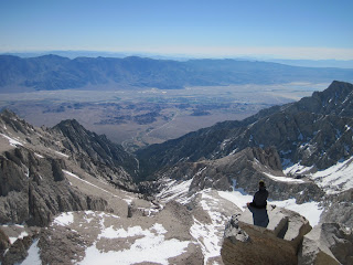
I am officially at mile 1293, in Quincy, CA. The snow has almost ended, so the miles will start melting away. The last time I wrote I was half way through the Sierras. I left Bishop, CA with 6 other hikers, then 3 of us split off to go on our own. It becomes a little difficult to make decisions with that large of a group when navigating. We had purchased extra detailed maps for this section since the guidebook only provides a quick reference.

Snow stories:

1. We camped above 10,000 feet on a cold night and woke up with frozen shoes! They would not bend in any direction and I could not put them on. So I had to pour a pint of water on each shoe to loosen them up! Who needs coffee when putting on frozen shoes in the snow.

2. Every day I acquired a memory of the trail, through scrapes and cuts. Everyday I would have some accident to cause some small wound. I once post-holed in the snow and racked my knee on a rock. It gave me a wound like a baseball raspberry from sliding in to a base.

3. One night we came upon a river that we were supposed to ford (cross) by wading. If we had crossed where the trail went, we would have been chest high. Once the water gets over your stomach (center of gravity) it becomes very difficult to stay on your feet. We decided to wait until morning when the river would be lower. So, we hiked up the shoreline to find a better place to cross, tried two or three places without luck, and came to a tributary creek. This side creek was as deep and wide as the main river! We were stuck! We either turn back a and look for another way, or we swim across. One of the hikers I was with had an inflatable sleeping pad called a Neoair. He blew it up and one by one we swam across fully submerged, but our packs stayed above the water. Did I mention this was at 6am, the water was in the 30's F with the air in the 40's F. All made it safely and we warmed up after 2 hours of hiking!

Toilette Humor

If you do not want to hear stories of human waste, please skip this section.

1. One of the hikers ended up with fecal matter on their shorts. But they could not figure out whether they did it with their shorts on or while performing the evacuating deed.

2. One day I had horrible, horrible flatulence. I farted so hard that I pissed myself a little.

3. I was using an outhouse at a public campground. I tend to visually inspect the receptacle prior to sitting, this time was no different. As I peeked in I saw the bottom about 8 feet a way, great! As I proceeded to sit and evacuate, the first drop produced a back splash so high that I became wet where I was once dry! First thing in the morning I had a wet ass!! My co-hikers only heard profanities coming from the tiny building and then me kicking open the door in disgust (after I cleaned up). I was scarred after that one.

4. At another out house I was having a movement and sneezed at the same time. The discovery I made was the back pressure created sped up the evacuation process.

Over the last week I was pushing hard on my own to get to Quincy to catch my flight. I left my buddies behind in South Lake Tahoe to do long miles. My first day out was 10, but I had started at 4pm. Then the next 3 days were 30 milers. I hiked 5 miles into town and took the rest of the day off in Sierra City. Then repeated three 30 milers into Quincy. I was whooped!! There was still snow for 40-50% of the trail, and I was hiking from 5 am til 8 pm. Along the way though I saw a yellow bellied marmot and her 2 pups, a barred owl and her two fledgelings, and a mama bear and her two cubs (one was climbing down a tree). It was a good challenge but I look forward to getting back and doing 20 to 25's at a relaxed pace. I'll be at the official half way point my second day back on the trail. I am in Florida now. Just went to my sister's wedding, hanging out with a few friends, will work Monday, and fly out Tuesday, July 13.

One last story that I keep forgetting to write, is about food. A hiker had bought a soup mix for dinner out on the trail. She made it and couldn't finish so offered me the rest. I should have been suspect since she has never offered before. It tasted like a bullion cube! She didn't reed the large print on the front of the package that said makes 5 quarts. She had only used 16 ounces of water, 1/2 quart! She had a pulse of 140 before going to sleep, had some chest pain, but it all subsided the next day.

Peace out!!


Thursday, June 10, 2010

It's been so long!!


Sorry for the delay, the last two town stops have been a bit rushed. From Agua Dulce to Kenedy Meadows, I finished the last of the desert. It was a bit rough, and after a night of whisky, beer and tacos, I decided to pack out a pint of whisky for the hike. It was a nice nightcap after some long hot days. We ended up doing a night hike over the Los Angeles Aquaduct due to the heat and lack of scenery. Around 6 a.m. when the sun came up we took a break and created a new morning beverage. You take a heaping spoonful of instant coffee and chase it with a shot of whisky. It was named either the dirty deuce or cafe whiskay. Another day we hiked through one of the world's largest wind farms located in Tehachipi, CA. Several times I was almost knocked over due to the strong winds.


On another day, 5 of us tried to hitch into town to get a meal. Believe it, we caught a hitch in an RV. They were returning from the "Mule Days," which entail many events involving mules including a chariot race. Our ride did not win the race but flipped their chariot during the show.


One night we were at a campground and someone had left their horse untied. All night long he was feeding all around us, we kept waiting for the animal to trample us, not much sleep at all.


Once we arrived in Kenedy Meadows, as usual I went straight for beer. Unfortunately I was dehydrated from the desert and hadn't eaten a thing. Three beers in and I was done for at 5:30 pm. Talk about a lightweight!!! The only thing in KM is a general store so it is where we spent most of our time. I learned a new game called washers. Just like horseshoes, but with washers. Takes a few drinks to warm up.


The Sierras!!!!


Before entering the Sierras, most people beef up their pack weight by adding an ice axe, microspikes, a bear canister, and warmer clothes. This additional weight is a challenge along with the rugged terrain of the Sierra Mountains. I packed out all of this and six days of food. The first day out we did 25 miles, with little snow. The next day we were in snow for half of the day. Snow adds several difficulties to the hike. First is the snow condition. Is it hard, soft, icy etc. In the morning it is usually hard, and if the slope is steep enough, microspikes (snow chains with spikes for your tennis shoes) are necessary. In the afternoon the snow softens up. If your going downhill, you can almost run because the snow absorbs the impact. But if is level ground, you may post-hole, that is ending up knee to waist high on every step, pretty exhausting. Despite the extra effort it has been gorgeous with great views. You cannot take a bad pic here.


The other difficulty of snow travel is the lack of trail. We are navigating approximately 90% of the time. But I have become comfertable in reading a map. On our 4th day out we summited Mt. Whitney, the tallest peak in the lower 48, around 14,500 ft. This involved river fording, walking across snowfields, rock climbing, walking across icy ledges, etc. My hardest day on the trail yet. But so worth it!!! It's hard to slow down after a day like that, your constantly in the moment because of the risk in every step, the exertion needed, and the control of your fears.


The following day we crested two major passes, one of them named Forrester. Again all snow, and we were only on the actual PCT for the crest of the pass.


Now I am in Bishop, after a 50 mile hitch enjoying lots of food, a hot shower, and of course beer. I have been looking for live musit but it doesn't seem to exist in these small towns. The next half of the Sierras I will slow down because of the snow. It is almost twice the exertion as regular trail.


On one of the river crossings a fellow hiker fell in. Luckilly he grabbed some branches and pulled himself to shore. In the process he lost his GPS and a trekking pole, and came out soaking wet. This happened at 5 am in a snow melt river. He didn't warm up til noon, while wearing my fleece and raincoat throughout. All is well although he's a little more hessitant around creek crossings. The best way with a strong current is to face upstream and walk sideways. Trekking poles definitely help. The creeks are unusually high this year due to the heavy snow fall and recent heat wave.


Here is the anser to a few questions my friend Chris asked:


1. Pack weight: base weight without food or water is about 15 lbs. With 5 days of food and a liter of water about 30 lbs. For the Sierras adding the ice axe, microspikes, bear canister and clothes, my base weight is about 20.


2. My tarp provides no protection from bugs, but they have not been bad. I will get a bug net in Oregon and Washington due to the chances of rainfall.


3. Water was very scarce in the desert, but people leave water for hikers at designated spots. In the snow areas there is no problem with water.


4. My ice axe length is 70 cm and I like the length. It is all a matter of preference. I like the long one because it almost acts a another trekking pole on the slopes.


5. This trail is less crowded than the Appalachian Trail. Around 3000 people start the AT, only 300 start the PCT.


I still cannot believe I am out here!! Great people and beautiful places. Talk to you soon!


Crow Dog

Saturday, May 22, 2010

Hiker Heaven!


Well, I am writing you all from the infamous Saufley's Hiker Heaven. They are a couple that runs a hostel free of charge in Agua Dulce, CA. They are running a makeshift post office out of the garage along with a laundry facility, a tent city, single wide trailer for cooking and showers, etc. The town is an equestrian community with a local rock outcropping which many movies were filmed.


As for my last stretch of trail: I hiked over a mountain called Baden Powell, another snow covered mountain. On the way down I spotted a bear and got some pics that were too far away. That night I camped at a stream and didn't realize the bones on the ground til morning. Turned out to be two full stripped carcases of some unlucky big horn sheep taken down by a mountain lion.


The next two days were road walking due to a reroute of trail from last years fire. NOT FUN!!! It feels like you are on a treadmill. Then yesterday coming into town I was within 6 inches of stepping on a rattlesnake. It was the first time that I've jumped probably 5 feet with a full pack on.


Coming into town at 2pm I went straight to the cafe and ordered 3 milkshakes, burger and fries, and a pitcher of beer. Had to fill up before I went to the grocery store!


I will be recieving mail drops at the following address if anyone is interested.


Attn PCT Hiker: Michael Huff


Kenedy Meadows General Store


96440 Beach Meadows Rd


Inyokern, CA 93527


Sorry I haven't gotten back to each of you individually, just limited on computer time and a little brain dead after hiking in the desert. Hope all is well in all your lives, walking through the Mojave next!

Monday, May 17, 2010

Above is one of the rattlesnakes I have seen, the desert is below, along with my summit of Mt. Marion.


And of course the tarantula!


So this last stretch was fairly mellow for elevation gain and loss. We do end up crossing an interstate where there is a McDonald's .4 miles from the trail. Yes, I ate at McDonald's! I had 4 breakfast burritos, a hash brown, and an OJ. Then went next door at the gas station for ice cream. Legend has it that a thru-hiker challenged a 400 lb woman to an eat off at McD's and the thru-hiker won. After that we had a detour around a burned area. The rest is history and I am in Wrightwood, CA, mile 373!

Sunday, May 9, 2010

Big Bear Lake, CA

Well I am taking my official second day off. On the trail these are called "zero days." This means that you have hiked no miles that day. I just got done with 6 days out: 17 miles, 12 miles, 13, miles, 30 miles, 19 and 10. My pack was a bit heavier with an ice axe and microspikes (crampons for tennis shoes that help you walk in the snow) along with all the food. On day two and three I had to deal with hiking on snow and navigation, two things I have never done! Definitely burned more calories and had a higher level of stress. The area is named the San Juacinto Wilderness, near Idyllwild, CA. On day three I decided to summit Mt. Marion at around 10,388 ft above sea level. After that I descended and glacaded for the first time. Here's how it works: sit on your butt start sliding on the snow, then use the pick on your ice axe as a rudder and a brake. Lots of fun and very fast, but I snapped one of my shoulder straps in the process.
On day four I did a 30 miler on easy terrain, and ended up camping on the Whitewater River. We arrived around 4 pm and swam for an hour after the long hike through the desert. A perfect day.
New trail names: Jaybird, Sir-Mix-A-Lot, April Showers, Structure, and my favorite yet: Beer Gryllis-Man vs. Beer.
New animals: bat, kit-fox, 5 different lizards, centipede.

Still having a problem getting pics, I may start a photobucket account and I'll send out the link. Happy mothers day!!

Thursday, April 29, 2010

Warner Springs CA

Had to start the trip off on the right foot with the airline sending my bag to Chicago while I went to San Diego. I was able to pick it up later thanks to my ride (Carolyn and Cush). First time I have checked my bag in 5 years!! So my ride to the trailhead began with being dropped off at the border in Campo, CA. I had to see at least 30 border patrol SUV's and 1 ATV. They asked me to see the bottom of my shoe. Apparently they 1) drive the length of the border leaving treadmarks 2)patrol the same road with the unmanned airplane mounted with a camera checking for footprints on those same treadmarks. They were looking at my shoes to make sure I did not match anyone they were looking for that night. This all occured at 7:00 pm, almost dark. So I hiked for 4 miles to reach a creek for camping. Woke up early and headed into Lake Morena 17 miles later. The desert was in full bloom due to the high rain fall this year. The next 5 days of mileage were: 19, 23, 18, 24, and 8 miles into Warner Springs.
Interesting names: On these long distance trails, hikers are usually given a name to use while they are on the trail. It usually is based on some embarrassing moment. Here are a few: Karma, Cow Whisperer, Jester, Balls, Smiles, and the most memorable so far, Assface.
Interesting stories:
1) I bought a pair of hiking shorts with an underwear liner in them. Well, these cause me to "chafe" so I had to cut them out. The strange part is that I did this while the shorts were still on, very carefully.
2) I was hiking along the trail and came across a fellow hiker sitting down. He had claimed to have a tick in his belly button and asked if I knew a way to get him out. I responded with 2 answers, pull it out or apply heat to it to make it back out. He chose both and heated up his tweezers and tried to pull it out. He ended up burning half of the body with the tick still embedded. Unsatisfied with the results, he pulled out his lighter and tried to apply a direct flame to the tick! One try and he burned half the hair on his stomach, that's when I left.

Animal list: 1 rattle snake, 3 humming birds, tons of lizards, heard the howl of some wolves, red tail hawks, coyotes barking, and lots of small birds.

Well that is all for now. There are some sketchy sections of trail that have some ice and snow, so I had my mom mail me my ice axe. Also this computer doesn't have a USB port access so no pics yet. Til next time!!

Wednesday, April 21, 2010

Mexican Border Tomorrow!!!

Hola!! Well, after leaving Sarasota, I stopped in Orlando and Gainesville to see friends. My friends fiance in Orlando asked me a question I have never been asked about backpacking: So, do you lock up your tent @ night? After a good laugh I said no, a knife would make access to the tent around the lock. Now I am in Knoxville, TN hanging out with my folks. I went zip-lining with my mom today and then a hike in the afternoon. My flight is tomorrow and I will arrive in San Diego @ 1:00 pm. My ride, which I am grateful for, is dropping me off @ the Mexican border. I'll hike a few miles til sunset, and then the rest of the way to Lake Morena on Friday.
There is a festival called the Kick Off every year for the PCT. It is a place for former and current hikers to get together and talk about the trail, gear, and have a few beers. I will be there Friday and part of Saturday.
Next post I will put put up some photos to show my setup of pack and tent. Less than 24 hours and I'll be on the trail!!!! Few more beers and some sleep b4 I set off!


Sunday, March 28, 2010

What am I bringing? As little as possible!

Well, since I have done an extensive hike before, my mind is programmed to reduce weight as much as possible when carried by "me". So I have decided to construct my own pack and shelter (tarp) to reduce weight and do it economically. All of my other gear (except my stove) was store bought. Eventually I may attempt making rain gear and other clothes, but for now I don't have the time. Here we go:

Backpack
Tarp
Sleeping bag
Sleeping pad
Ground cloth
1 large trashbag
2 trekking poles

Stove (with wind screen)
1 pot
Fuel (denatured alcohol)
Spoon
Small green scrubber


Long johns
T-shirt
1 pair shorts
Fleece top
Rain jacket
3 pairs of socks
warm hat
Baseball cap
2 bandanas
Tennis shoes (with an upgrade for inserts)
Ankle high gaiters
Sunglasses
Analog/digital watch


Small flint
1 lighter
2nd skin and adhesive bandages (blister care)
Ibuprofin and excedrin
Pocket knife
Toothpaste
Toothbrush
Floss
Nail clippers
Head lamp
Sunscreen
Duct tape
Chap stick
Small wallet
100 ounce Camelbak bladder
Camera (w/charger, cable, spare battery, thumb drive)

Guidebook
Something to read
Journal
1 Pen
1 Pencil

5-7 days of food
1-3 liters of water

In central California I will pick up additional gear that will be mailed by my folks. This is due to the high Sierras. This mountain chain requires hiking at higher elevations along with leftover snow from the winter still on the ground in June . There is also a greater chance of a bear encounter. So here are the additions:

Ice axe
Rain pants
Sleeping bag liner
Bear canister
I am sure there is something that I have forgot, but this is it for the most part. I should have a base pack weight soon, which will not include food and water. More to come soon!!


Friday, March 19, 2010

Intro

Hello all! I am writing this blog to post my thoughts and experiences during my 5 month long hike of the Pacific Crest Trail (PCT). For those of you who do not know, the PCT is a 2650 mile trail running from Mexico to Canada through the states of California, Oregon and Washington. This will potentially be my second thru-hike, as I completed the Appalachian Trail in 2003. I will be starting my hike somewhere around April 23-25, and ending sometime late September or early October. Water will be available at seeps, streams, creeks, rivers, and lakes, although in southern California, hikers will rely on water drop points at road crossings. This is due to the desert-like conditions in southern Cal. For food I will buy from grocery stores as I go, by hitching into a town, shopping, and then hitching back to the trail.
Well, that is all for now! 36 days and counting til I start walking.